To many people who are fascinated by Sydney's native flora but have no formal training in geology, the rocks around and about are generally thought of, in simple terms, to consist either of sandstones, shales or volcanic rocks. To express this in a crude stratigraphic way there are believed to be Wianamatta shales lying above Hawkesbury Sandstone which in turn rests on Narrabeen shales. Plus there are the volcanic diatremes of course.
‘Narrabeen shales’ is a term you often hear and read especially when plant communities like Pittwater Spotted Gum Forest and coastal clay heath are described, even in the formal sense by qualified botanists, and generally refers to the Newport Formation. But this term grossly misrepresents the reality, so firstly let’s look at the Narrabeen Group in more detail.
The Narrabeen Group
This group has the widest distribution of any major suite of rocks in the Sydney Basin making up much of the Greater Blue Mountains and covering a vast swathe of the Central Coast and its hinterland. It reaches a maximum thickness of something like 800 m (by comparison, the Hawkesbury Sandstone reaches roughly 250 m in thickness). It could be argued that ‘Narrabeen’ is a poorly chosen type-locality name because, although the group is a collection of 21 distinct formations scattered across the basin, only two of them are present in full on the Northern Beaches, plus just an isolated seashore outcrop of a third one.
Local Formations of the Narrabeen Group
1. Bulgo Sandstone
The ‘isolated seashore outcrop’ is of the Bulgo Sandstone, the top 10 m of which just, but only just, breaks surface on the outer tip of Long Reef. However, out under the sea, deep drilling for the ocean sewage outfall passed through 200 m of Bulgo Sandstone.
Commonly a grey-green colour when fresh, the Bulgo Sandstone can carry, in addition to quartz, a high proportion of grains of volcanic rock of a type similar to those classic columnar-jointed lavas you see on the coast at Kiama; therefore it bears only passing resemblance to the (very quartz-rich) Hawkesbury Sandstone. You can see the Bulgo Sandstone in full at the southern end of the Royal towards Bulgo village where it forms a stunning cliff line; and its pebbly, more quartz-rich lower layers host the famous Figure 8 Pool.
The Bulgo Sandstone's volcanic sand grains break down under weathering to clays leading to the common misconception that the southern slopes of the Royal are over a shale sequence. These clay-rich soils are much deeper and more fertile than those developed over quartz sandstones, and also have inherited plant nutrients from the sandstone's volcanic component, which helps in their hosting of a diverse littoral rainforest community.
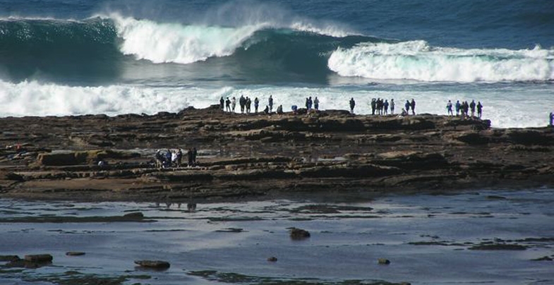
In the photo at the top of the page, facing the full brunt of the waves, the topmost 10 m of the Bulgo Sandstone emerges and protects the soft Bald Hill Claystone of the Long Reef rock platform from being washed away into the Tasman Sea.
 2. Bald Hill Claystone
Overlying the Bulgo Sandstone, the Bald Hill Claystone is a strange and remarkable rock by any standards. It's not a shale but the name ‘claystone’ means, like shale and mudstone, it's made largely of clay minerals. It's crumbly but only locally truly shaley.
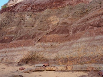
Also, its kaolinite is stained a deep, dull red-brown (some say chocolate colour) by hematite which, like the kaolinite, was the result of recurrent contemporary weathering of layer upon layer of fine volcanic debris 248 million years ago in early Triassic times. You can see grey-green bands of sandy or gritty debris interlayered with reddish claystones in the cliff faces and platforms at Long Reef.
Bald Hill Claystone at Long Reef is also well known for its Triassic ‘paleosols’ – fossil soil profiles in which you can even recognise ancient root traces.
Red is the prominent colour of the Bald Hill Claystone but you will notice here at Long Reef that the red beds are interlayered with light coloured, greenish-grey bands made of sand grains derived from weathering of volcanic rocks.
In the Northern Beaches, the claystone only supports vegetation on Long Reef Point, though well to the south it's present below the Hawkesbury Sandstone cliffs of the Illawarra Escarpment from the Royal to at least as far as Fitzroy Falls: its formal type locality is actually Bald Hill at Stanwell Tops.
At Long Reef Point it hosts heathland, shrubland and Themeda Grassland, but with a major problem of invasive bitou bush.
3. Newport Formation
The Newport Formation rests above the Bald Hill Claystone via a transitional few metres of a curious, spotted volcanic ash deposit called the Garie Formation.
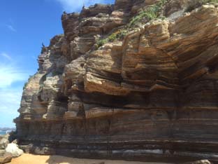
You can see a thinned version of the Newport Formation in the cliffs of North Garie Head in the Royal, then northwards it dips below the sea before surfacing low on the North Head cliffs – you can view its 15 m thick laminite and ledge-forming flaggy sandstones from the first lookout walking clockwise round the Fairfax Walk. However, it's much easier to see the formation in the cliffs from Narrabeen northwards where it consists mostly of thinly bedded sandstones and laminites with lenses of conglomerate (see photo).
Northwards along the coastline and across Pittwater into the Hawkesbury estuary there is a thickening and coarsening of the sandstones, and you can easily see this on Barrenjoey and Lion Island where only the topmost quarter of their thick sandstone cliffs belongs to the Hawkesbury Sandstone. You can often strain your eyes deciding where one formation finishes and the other begins, though the Newport sandstones tend to have dirtier, rustier weathering surfaces. The sandstones are impure quartz lithic ones and locally interbedded with laminites which are exposed especially north side of Lion Island where the formation has undergone a name change to Terrigal Formation.
The Newport Formation is host to some important plant communities. Its sandstones and laminites of the coastal cliffs weather to a stony, clay-rich soil which supports coastal clay heath and endangered Themeda Grassland. But traverse the peninsula and this all changes to pockets of littoral rainforest intermixed with endangered Pittwater Spotted Gum Forest. The host soils are weathered, thick quartz lithic sandstones with intermittent laminite layers – but definitely not shales.
Thick sandstones persist westwards and upstream into the Hawkesbury estuary but the tree species change, the principal eucalypt becoming Angophora floribunda comprising the Rough-barked Apple–Forest Oak Forest community defined by Smith & Smith in their plant survey projects for Hornsby and Warringah shire councils.
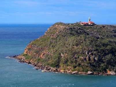
Barrenjoey lighthouse is built on a capping of Hawkesbury Sandstone but the lower two thirds of the headland is coarse-grained, rusty weathering sandstones of the Newport Formation which are the host rocks of the endangered Pittwater Spotted Gum Forest
This is the first in a series of articles by John Martyn describing his exploration of Sydney’s geology.