
The name Wianamatta is familiar through the loose usage of the term ‘Wianamatta Shale’ to embrace the Triassic rocks that overlie the Hawkesbury Sandstone. This is an informal term, distinctly woolly in its definition, and should be avoided, but if it must be used, ‘shale’ or ‘shales’ should always be spelt lower-case.
Wianamatta Group, derived from the Aboriginal name for South Creek, was established formally in 1952, fully documented in 1954 and further revised in 1979. The group consists of three formations: the Ashfield Shale, Minchinbury Sandstone and Bringelly Shale. It occupies the centre of the Sydney Basin, lapping onto the lower Blue Mountains and extending southwards to the Southern Highlands. It has been defined largely from drillhole data because outcrop is mostly limited to road and railway cuttings and quarries.
The thickest stratigraphic section drilled was encountered in hole DM Razorback DH1 on
Mt Hercules near Picton. This passed through 304 m of Wianamatta Group strata consisting of 257 m of Bringelly Shale, 2 m of Minchinbury Sandstone and 45 m of Ashfield Shale.
The Ashfield Shale and Minchinbury Sandstone correlate well across much of the 50 km long area covered by the same Department of Mineral Resources drill program, whereas the Bringelly Shale is much less uniform, its variability enhanced by the presence of many scattered sandstone lenses of limited lateral extent but up to more than 40 m in thickness that are hard to correlate.
The Wianamatta Group was deposited on a coastal lowland subject to early minor marine incursions. The depositional environment evolved upwards into lagoonal or marshy lowland crossed by meandering rivers that brought surges of sand that filled channels and created the sandstone lenses.
Ashfield Shale
The Ashfield Shale has a maximum drilled thickness of 61.6 m at Erskine Park near the centre of the basin and has been subdivided into four members consisting of alternating layers of dark ferruginous shale and laminite.
All of these members were once incompletely exposed in the Thornleigh brick pit but this has since been filled in. Now, the most viewable Ashfield Shale faces can be found along the North Shore and Northern railway lines and Bells Line of Road, and in a number of other road cutting exposures such as Horace Street, St Ives and in the Picton–Campbelltown area.
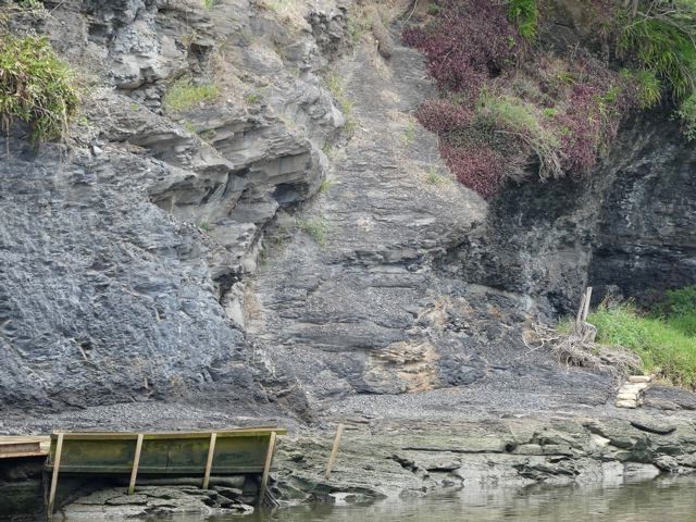
The best natural exposure is the river-cliff in Mulgoa Nature Reserve south of Penrith which exhibits dark coloured Mulgoa Laminite Member, and also the river-cliff opposite the Parramatta ferry wharf (see photo). The Mulgoa cliff is visible from Mulgoa Road through gaps in a screen of riparian forest but is difficult to access on foot.
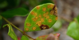
An important feature of the Ashfield Shale is its relatively high phosphorus content of between 0.1 and 0.9% P2O5. This is in strong contrast to the negligible amounts of phosphorus in the underlying Hawkesbury Sandstone and is also significantly higher than levels in the Bringelly Shale. Phosphorus values in Ashfield Shale measured from drill core tend to be spiky with prominent peaks, and it appears the element resides in thin beds rich in phosphatic siderite nodules.
Minchinbury Sandstone
The Minchinbury Sandstone is a widespread but thin (less than 6 m) marker band of fine-grained, bluish-grey, brown-weathering rock that is rarely seen in surface outcrop and is known mainly from drill intersections. It is a quartz lithic sandstone with grains mostly of quartz with about 10% of rock grains. It also contains calcite, plus micas, notably muscovite which can be seen sparkling on broken surfaces. Another very similar, intermittent sandstone bed lies immediately above in the lower Bringelly Shale. Both sandstones weather deeply to a crumbly or flaky condition and surface expressions are subtle, or the sandstone outcrops are smoothed over by soil profiles or pasture.
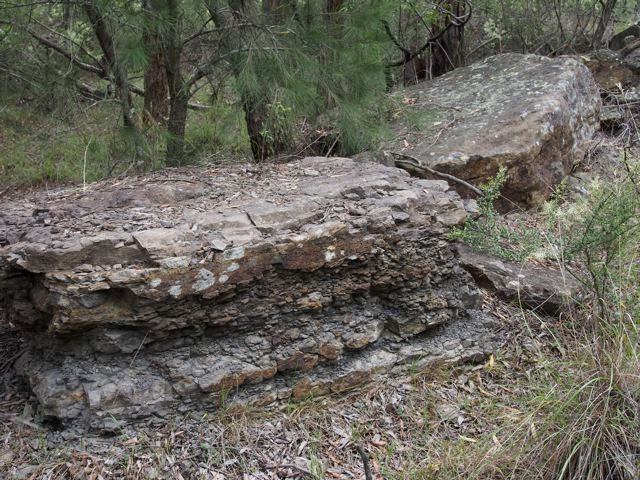
Minchinbury Sandstone at Minchinbury is more than 100 m deep in a borehole, and finding its outcrops elsewhere, especially natural ones, is a challenge. Near the top of the Mulgoa shale cliff there is a thin (less than 1 m) band of very fine-grained flaggy sandstone which has been interpreted as Minchinbury. In Lansdowne Park (see photo) there is a train of large, disjointed sandstone slabs whilst other small outcrops and floaters are scattered along a low, hillside bench. There are a few others, but if you happen to know of any more, please let me know.
Bringelly Shale
The Bringelly Shale is the uppermost formation of the Wianamatta Group and also the youngest Triassic sedimentary unit in the Sydney Basin. Reaching more than 250 m in the south, it is also one of the thickest.
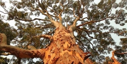
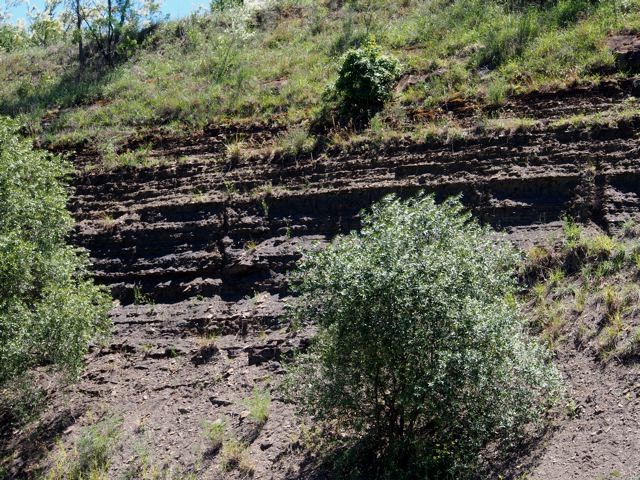
The commonest rock type exposed is a mixture of finely-bedded shale, laminite and siltstone. Seen in road cuttings this differs from the dark, almost black, clay-mineral-rich Ashfield Shale, being more variable, often accompanied by disconnected sandstone lenses that become thicker and more prominent from Western Sydney Regional Park southwards, forming most of the hilly country between Campbelltown and Picton. Driving south or into the Picton area you can't miss them. They form intricate escarpments up to 200 m high, and the sandstone cliffs along the old Hume Highway near Picton (see photo) are of the two thickest ones, the Mt Hercules and Razorback Sandstone Members (see photo at the top of the page).
Such sandstones have been described as lenses and stacked multiple lenses and have been interpreted as infill deposits in channels created by rivers meandering across the swampy lowland. Their lateral extent is not great and they are difficult or impossible to correlate with one another across distances of more than a few kilometres, but they are important in defining the landscape, their scarps and hollows nurturing sub-types of endangered Cumberland Plain Woodland floras.
Ashfield Shale Floras
Ashfield Shale outcrop extends to higher elevations and into higher rainfall areas than Bringelly Shale. These include the North Shore where rainfall zones exceeding 1000 mm, and similarly the Bilpin–Mountain Lagoon area. Where the shale forms cappings that fringe the Illawarra escarpment the mean annual falls may exceed 1500 mm by a significant amount.
Blue Gum High Forest is familiar to most STEP members and needs little description here. Most members live within 10 min drive of Dalrymple-Hay and Sheldon Forest or can easily reach more far flung localities like the Blackbutt forest of Galaringi Reserve or the Blue Gum, Grey Ironbark forests of Rapanea Community Forest, both in the Carlingford area. But even more diverse treats are in store in the Blue Mountains where the Mountain Blue Gums Eucalyptus deanei and Monkey Gums E. cypellocarpa grow tall and stately in the endangered Blue Mountains Shale Cap Forest of the Bilpin area. These two are members of a cornucopia of eucalypt species as the community grades laterally into Sydney Turpentine Ironbark Forest and Shale Sandstone Transition Forest. Appearing are Grey Ironbark, Mountain Mahogany E. notabilis, Grey Gum, White Stringybark, Sydney Peppermint, and of course not forgetting Turpentine.
Have you visited the Illawarra Fly Treetop Walk at Knights Hill near Robertson? If not it's worth an outing, rounded off by a pie at the Robertson Pie Shop. The walk meanders through the crowns of two tall eucalypt forest species,
Gully Gum Eucalyptus smithii and Brown Barrel E. fastigata. Ashfield Shale sits atop a sheer cliff of Hawkesbury Sandstone protected by a large capping of Cenozoic basalt. The weather station at the pie shop records a mean annual rainfall of nearly 1600 mm.
Scheyville National Park near Pitt Town is perhaps the best place to look at lower rainfall communities on Ashfield Shale. It includes part of the former Pitt Town Common grazing lands whose pasture merges into tracts of quite dense woodland and forest. The dominant plant community is the critically endangered Cumberland Plain Woodland whose principal tree species are Grey Box Eucalyptus moluccana, Forest Red Gum E. tereticornis and Narrow-leaved Ironbark E. crebra. The forest floor is often grassy and may be sprinkled with quite delicate wildflowers like Blue Trumpet Brunoniella australis in spring and summer. Cumberland Plain flora shares many herb and shrub species with the tablelands and slopes of NSW but in the grassy ground flora you'll also be reminded of aspects of Blue Gum High Forest.
Bringelly Shale Floras
The Minchinbury Sandstone is so thin and it weathers so readily that, vegetation-wise, it is inseparable from the Bringelly Shale (or for that matter the underlying Ashfield Shale).
The Bringelly Shale supports a more varied range of Cumberland Plain plant communities than the Ashfield Shale described earlier. Because of the presence of sandstone beds and lenses, its country can be quite hilly, with sheltered slopes and valleys, and this has led to the creation of Shale Hills as distinct from Shale Plains woodlands as Cumberland Plain Woodland subtypes. Sheltered valleys and steep slopes have also nurtured additional communities such as Western Sydney Dry Rainforest and Moist Shale Woodland, both also listed endangered. However, rainfall nowhere reaches levels that would support tall blue gum forests like those on Ashfield Shale in Sydney’s upper North Shore or the lower Blue Mountains.
Reserves carrying native vegetation on Bringelly Shale are relatively small, widely scattered and often subject to weed invasion especially by African Olive, Lantana, privet species and African Lovegrass. They include Lansdowne Park, remnant pockets within Mt Annan Botanic Gardens, Mulgoa Nature Reserve, Shanes Park, and Wianamatta and Western Sydney Regional Parks including Kemps Creek.
In Western Sydney Regional Park you can wander from the main park areas into quite dense Spotted Gum forest, and into sheltered niches below escarpments formed by sandstone lenses which carry Moist Shale Woodland and Western Sydney Dry Rainforest, with odd ring-ins like White Mahogany Eucalyptus acmenoides amongst the Spotted Gums and Forest Red Gums. Understory species include Mock Olive Notelaea longifolia and Hairy Clerodendrum Clerodendrum tomentosum. Climbing plants are particularly diverse and include native Grape Cayratia clematidea and Gum Vine Aphanopetalum resinosum (from personal experience, too aggressive to grow in the garden).
Main reference: Herbert, C. (1979) The Geology and Resource Potential of the Wianamatta Group, Geological Survey of NSW Bulletin 25
This is the fourth in a series of articles by John Martyn on Sydney’s geology.