Displaying items by tag: geology
Geology of the Sydney Basin
Our local and regional environment owes so much to its geological heritage. We live in the Sydney Basin, an epicontinental pile of sedimentary rocks several kilometres thick that was laid down in the Permian and Triassic periods between 300 and 200 million years ago, and our present landscape framework was created by tectonic uplift and erosion of its strata.
Abundant life in a chilly sea
We might think of our local landscapes in terms of its multiple sandstone tablelands, spurs and gorges. Their rocks were mostly laid down by fresh and brackish water in flood plains and estuaries, but the early history of the Sydney Basin incorporates a strong marine influence, and you can find abundant shelly fossils in numerous sites along the coast south of Wollongong. There's also much evidence that the sea at the time was icy cold and peppered with drifting, melting icebergs, and you can still view their dropped erratic, morainic boulders nestling amongst the fossils in cliffs and rock platforms. The mineral glendonite found down there only forms today in icy-cold sea floor mud – it was named after its discovery site at Glendon on the Hunter River. The global climate conditions captured by this older Sydney Basin suite is of national significance both to our scientific heritage and to a broader understanding of the earth's history.
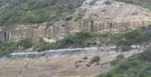
A great extinction event
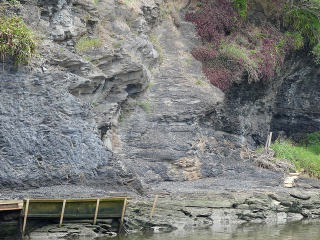
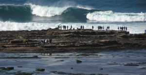
Towards the close of that chilly, early basin epoch, the seas gradually subsided and coal formed from the peat of boreal swamp forests, contributing historically to our region's strong economic base. But the coal story came to an abrupt end 252 million years ago with the great end-Permian extinction event, when massive volcanic outpourings on the far side of the globe bathed the planet in acidic gloom and warmed and dried its atmosphere.
The evidence is beautifully preserved in cliffs south of Newcastle (pictured), north of Wollongong and also in the Blue Mountains.
This key event should be much more widely recognised and understood as its effects are mirrored in current climate change and extinctions. Our local geological heritage carries critically important environmental messages for today.
Plain old sandstones reveal fascinating stories
Some of our local sandstones were sourced from a long way off. Research on the Hawkesbury Sandstone based on radiometric dating has matched grains of a mineral called zircon with the same mineral in igneous rocks of the Transantarctic Mountains. Antarctica was joined to Australia at that time, and while still a long way off, the scale of the river system implicated is well within that of many flowing across present day continents.
Australia's membership of the supercontinents of Pangaea and subsequently Gondwana was the beginning of a story that flows right through to the roots of our floral diversity. Clearly it underpins our natural heritage.
Our sandstone's floral diversity
Our sandstone landscapes are built largely from nutrient poor but iron- and quartz-rich rocks that support an incredibly rich flora, many of whose species benefit from the buffering action of iron against phosphorus toxicity. The floral diversities of sandstone heathlands and shrublands in places like the Royal and Ku-ring-gai Chase are only surpassed in Australia by those of south-west WA, an internationally recognised biodiversity hotspot. Long term, the heritage value of our local bushland outstrips that of any of the temporary creations of human activity, however functional or beautiful they might be, and it must be preserved at all cost.
Dinosaurs, volcanoes and diatremes
The earlier paragraph on the great extinction event might also have mentioned that this kick-started the evolution of the dinosaurs, which of course ultimately led to the birds. The dinosaur era peaked in the Jurassic and Cretaceous periods between 200 and 66 million years ago before ending in that other great extinction event, and at that time the sedimentary rocks of the Sydney Basin were compacting and drying out.
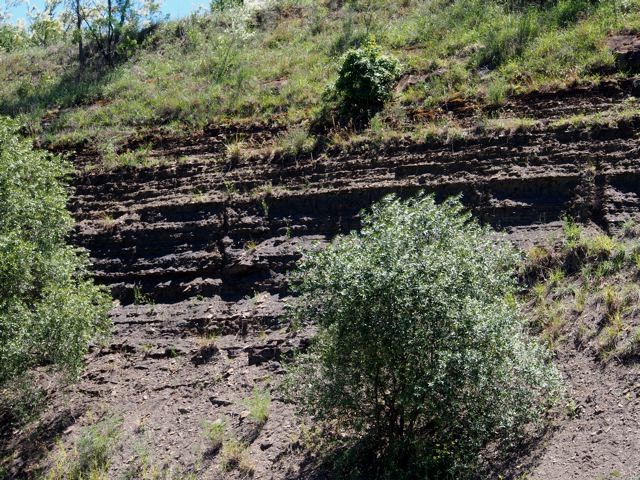
But there was still enough water left in their pores and joints that when basaltic magmas trickled in from depth, it flashed it into superheated steam that shattered its way to the surface at numerous points around the region. In many cases the magmas wormed their way through the crevices of shattered rock to follow it to the surface, also to be blown to smithereens by explosive pressures. The volcano style of that time is known as a maar, and its feeding pipe a diatreme.
In our northern Sydney region we have the largest and best preserved diatreme in Australia in the Hornsby quarry. This has heritage value and is a geological site of international status. Fortunately it appears the filling of the quarry for the parkland project has preserved the upper faces and cleared them of debris, thus exposing the diatreme's classic layered structure (pictured).
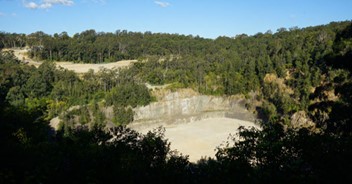
Layering in the volcanic debris of the Hornsby diatreme
Photo at the top of the page: Ghosties Beach Munmorah: black coal followed by white sandstone band marks the extinction event
Dr John Martyn
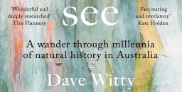
John Martyn’s New Book, Rocks and Trees
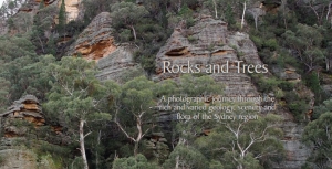
The perfect way to learn about the geology that underpins the landscape and diverse flora of the Sydney region
A photographic journey through the rich and varied geology, scenery and flora of the Sydney region
Rocks and Trees captures the dramatic scenery of the Greater Blue Mountains, the beauty of the coastline and the great sweep of plains west of the CBD, but its main purpose is to highlight the geology and flora and their interrelationships. The book journeys from the Illawarra along the coast to Newcastle and inland to the Greater Blue Mountains, staying within the framework created by the massive sandstones and conglomerates of the Triassic Narrabeen Group.
Wianamatta Group
The name Wianamatta is familiar through the loose usage of the term ‘Wianamatta Shale’ to embrace the Triassic rocks that overlie the Hawkesbury Sandstone. This is an informal term, distinctly woolly in its definition, and should be avoided, but if it must be used, ‘shale’ or ‘shales’ should always be spelt lower-case.
Wianamatta Group, derived from the Aboriginal name for South Creek, was established formally in 1952, fully documented in 1954 and further revised in 1979. The group consists of three formations: the Ashfield Shale, Minchinbury Sandstone and Bringelly Shale. It occupies the centre of the Sydney Basin, lapping onto the lower Blue Mountains and extending southwards to the Southern Highlands. It has been defined largely from drillhole data because outcrop is mostly limited to road and railway cuttings and quarries.
The thickest stratigraphic section drilled was encountered in hole DM Razorback DH1 on
Mt Hercules near Picton. This passed through 304 m of Wianamatta Group strata consisting of 257 m of Bringelly Shale, 2 m of Minchinbury Sandstone and 45 m of Ashfield Shale.
The Ashfield Shale and Minchinbury Sandstone correlate well across much of the 50 km long area covered by the same Department of Mineral Resources drill program, whereas the Bringelly Shale is much less uniform, its variability enhanced by the presence of many scattered sandstone lenses of limited lateral extent but up to more than 40 m in thickness that are hard to correlate.
The Wianamatta Group was deposited on a coastal lowland subject to early minor marine incursions. The depositional environment evolved upwards into lagoonal or marshy lowland crossed by meandering rivers that brought surges of sand that filled channels and created the sandstone lenses.
Ashfield Shale
The Ashfield Shale has a maximum drilled thickness of 61.6 m at Erskine Park near the centre of the basin and has been subdivided into four members consisting of alternating layers of dark ferruginous shale and laminite.
All of these members were once incompletely exposed in the Thornleigh brick pit but this has since been filled in. Now, the most viewable Ashfield Shale faces can be found along the North Shore and Northern railway lines and Bells Line of Road, and in a number of other road cutting exposures such as Horace Street, St Ives and in the Picton–Campbelltown area.
The best natural exposure is the river-cliff in Mulgoa Nature Reserve south of Penrith which exhibits dark coloured Mulgoa Laminite Member, and also the river-cliff opposite the Parramatta ferry wharf (see photo). The Mulgoa cliff is visible from Mulgoa Road through gaps in a screen of riparian forest but is difficult to access on foot.
An important feature of the Ashfield Shale is its relatively high phosphorus content of between 0.1 and 0.9% P2O5. This is in strong contrast to the negligible amounts of phosphorus in the underlying Hawkesbury Sandstone and is also significantly higher than levels in the Bringelly Shale. Phosphorus values in Ashfield Shale measured from drill core tend to be spiky with prominent peaks, and it appears the element resides in thin beds rich in phosphatic siderite nodules.
Minchinbury Sandstone
The Minchinbury Sandstone is a widespread but thin (less than 6 m) marker band of fine-grained, bluish-grey, brown-weathering rock that is rarely seen in surface outcrop and is known mainly from drill intersections. It is a quartz lithic sandstone with grains mostly of quartz with about 10% of rock grains. It also contains calcite, plus micas, notably muscovite which can be seen sparkling on broken surfaces. Another very similar, intermittent sandstone bed lies immediately above in the lower Bringelly Shale. Both sandstones weather deeply to a crumbly or flaky condition and surface expressions are subtle, or the sandstone outcrops are smoothed over by soil profiles or pasture.
Minchinbury Sandstone at Minchinbury is more than 100 m deep in a borehole, and finding its outcrops elsewhere, especially natural ones, is a challenge. Near the top of the Mulgoa shale cliff there is a thin (less than 1 m) band of very fine-grained flaggy sandstone which has been interpreted as Minchinbury. In Lansdowne Park (see photo) there is a train of large, disjointed sandstone slabs whilst other small outcrops and floaters are scattered along a low, hillside bench. There are a few others, but if you happen to know of any more, please let me know.
Bringelly Shale
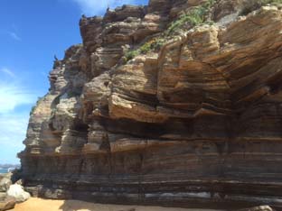
The Bringelly Shale is the uppermost formation of the Wianamatta Group and also the youngest Triassic sedimentary unit in the Sydney Basin. Reaching more than 250 m in the south, it is also one of the thickest.
The commonest rock type exposed is a mixture of finely-bedded shale, laminite and siltstone. Seen in road cuttings this differs from the dark, almost black, clay-mineral-rich Ashfield Shale, being more variable, often accompanied by disconnected sandstone lenses that become thicker and more prominent from Western Sydney Regional Park southwards, forming most of the hilly country between Campbelltown and Picton. Driving south or into the Picton area you can't miss them. They form intricate escarpments up to 200 m high, and the sandstone cliffs along the old Hume Highway near Picton (see photo) are of the two thickest ones, the Mt Hercules and Razorback Sandstone Members (see photo at the top of the page).
Such sandstones have been described as lenses and stacked multiple lenses and have been interpreted as infill deposits in channels created by rivers meandering across the swampy lowland. Their lateral extent is not great and they are difficult or impossible to correlate with one another across distances of more than a few kilometres, but they are important in defining the landscape, their scarps and hollows nurturing sub-types of endangered Cumberland Plain Woodland floras.
Ashfield Shale Floras
Ashfield Shale outcrop extends to higher elevations and into higher rainfall areas than Bringelly Shale. These include the North Shore where rainfall zones exceeding 1000 mm, and similarly the Bilpin–Mountain Lagoon area. Where the shale forms cappings that fringe the Illawarra escarpment the mean annual falls may exceed 1500 mm by a significant amount.
Blue Gum High Forest is familiar to most STEP members and needs little description here. Most members live within 10 min drive of Dalrymple-Hay and Sheldon Forest or can easily reach more far flung localities like the Blackbutt forest of Galaringi Reserve or the Blue Gum, Grey Ironbark forests of Rapanea Community Forest, both in the Carlingford area. But even more diverse treats are in store in the Blue Mountains where the Mountain Blue Gums Eucalyptus deanei and Monkey Gums E. cypellocarpa grow tall and stately in the endangered Blue Mountains Shale Cap Forest of the Bilpin area. These two are members of a cornucopia of eucalypt species as the community grades laterally into Sydney Turpentine Ironbark Forest and Shale Sandstone Transition Forest. Appearing are Grey Ironbark, Mountain Mahogany E. notabilis, Grey Gum, White Stringybark, Sydney Peppermint, and of course not forgetting Turpentine.
Have you visited the Illawarra Fly Treetop Walk at Knights Hill near Robertson? If not it's worth an outing, rounded off by a pie at the Robertson Pie Shop. The walk meanders through the crowns of two tall eucalypt forest species,
Gully Gum Eucalyptus smithii and Brown Barrel E. fastigata. Ashfield Shale sits atop a sheer cliff of Hawkesbury Sandstone protected by a large capping of Cenozoic basalt. The weather station at the pie shop records a mean annual rainfall of nearly 1600 mm.
Scheyville National Park near Pitt Town is perhaps the best place to look at lower rainfall communities on Ashfield Shale. It includes part of the former Pitt Town Common grazing lands whose pasture merges into tracts of quite dense woodland and forest. The dominant plant community is the critically endangered Cumberland Plain Woodland whose principal tree species are Grey Box Eucalyptus moluccana, Forest Red Gum E. tereticornis and Narrow-leaved Ironbark E. crebra. The forest floor is often grassy and may be sprinkled with quite delicate wildflowers like Blue Trumpet Brunoniella australis in spring and summer. Cumberland Plain flora shares many herb and shrub species with the tablelands and slopes of NSW but in the grassy ground flora you'll also be reminded of aspects of Blue Gum High Forest.
Bringelly Shale Floras
The Minchinbury Sandstone is so thin and it weathers so readily that, vegetation-wise, it is inseparable from the Bringelly Shale (or for that matter the underlying Ashfield Shale).
The Bringelly Shale supports a more varied range of Cumberland Plain plant communities than the Ashfield Shale described earlier. Because of the presence of sandstone beds and lenses, its country can be quite hilly, with sheltered slopes and valleys, and this has led to the creation of Shale Hills as distinct from Shale Plains woodlands as Cumberland Plain Woodland subtypes. Sheltered valleys and steep slopes have also nurtured additional communities such as Western Sydney Dry Rainforest and Moist Shale Woodland, both also listed endangered. However, rainfall nowhere reaches levels that would support tall blue gum forests like those on Ashfield Shale in Sydney’s upper North Shore or the lower Blue Mountains.
Reserves carrying native vegetation on Bringelly Shale are relatively small, widely scattered and often subject to weed invasion especially by African Olive, Lantana, privet species and African Lovegrass. They include Lansdowne Park, remnant pockets within Mt Annan Botanic Gardens, Mulgoa Nature Reserve, Shanes Park, and Wianamatta and Western Sydney Regional Parks including Kemps Creek.
In Western Sydney Regional Park you can wander from the main park areas into quite dense Spotted Gum forest, and into sheltered niches below escarpments formed by sandstone lenses which carry Moist Shale Woodland and Western Sydney Dry Rainforest, with odd ring-ins like White Mahogany Eucalyptus acmenoides amongst the Spotted Gums and Forest Red Gums. Understory species include Mock Olive Notelaea longifolia and Hairy Clerodendrum Clerodendrum tomentosum. Climbing plants are particularly diverse and include native Grape Cayratia clematidea and Gum Vine Aphanopetalum resinosum (from personal experience, too aggressive to grow in the garden).
Main reference: Herbert, C. (1979) The Geology and Resource Potential of the Wianamatta Group, Geological Survey of NSW Bulletin 25
This is the fourth in a series of articles by John Martyn on Sydney’s geology.
Sandstone-Shale Transition – the Mittagong Formation
The geology of the Sydney Basin changes dramatically at the top of the Hawkesbury Sandstone, which is followed upwards ultimately by the thick, shale-dominated Wianamatta Group. It isn’t an abrupt change but usually a transition, via several metres of alternating sandstones and shales called the Mittagong Formation. The quartz-rich sandstones of the Mittagong resemble finer-grained versions of the Hawkesbury Sandstone and they are interleaved with dark grey to black shales, siltstones and laminites.
Originally named Passage Beds by JF Lovering in 1954, the current name was adopted from a selected type locality, the Gib (Mt Gibraltar) railway tunnel at Mittagong, where the formation is 15 m thick. Elsewhere it is almost invariably less than 10 m and can locally be absent altogether. Exploratory drilling for the Epping to Chatswood railway tunnel at Macquarie Park, for example, encountered only a 2 to 5 m thickness of it.
The variability is in part due to the nature of the dwindling flood plain and braided river system which deposited the Hawkesbury Sandstone. This vast system eventually lost its strength and became a plain of scattered sandbanks, swamps and lagoons. Clays settled in the latter but were periodically overwhelmed by sand brought by late floods leading to a sandstone/shale alternation of very variable thickness.
For such a thin unit the Mittagong Formation has a disproportionate effect on vegetation because it usually creates a broad bench at the top of the Hawkesbury Sandstone’s steep rocky dropoffs and cliff lines. This leads to the retention of soils and can even collect downwash from overlying Ashfield Shale if present. Such level surfaces can also attract deep weathering and laterite formation.
Like the shale lenses in the Hawkesbury, Mittagong Formation forms richer soils than the sandstone but stonier, more lateritic and less fertile than those of the overlying Ashfield Shale. These yellowish soils are typically classified as belonging to the Lucas Heights soil landscape, highlighting similarities in the bedrock between Mittagong Formation and Hawkesbury Sandstone with its shale lenses in the Lucas Heights area.
Plant communities hosted by Mittagong Formation are diverse and usually gradational to those of adjoining shale or sandstone, often falling within the broad envelope of Shale Sandstone Transition Forest with either a sandstone bias or a shale leaning depending on setting. In other sites the communities may be more tightly defined in terms such as Sydney Turpentine Ironbark Forest, Turpentine Ironbark Forest, or where strongly lateritised, Duffys Forest. They tend to have one thing in common, they are mostly legally defined as threatened, mainly because they survive in narrow, disjointed enclaves isolated by land clearing.
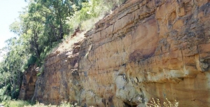
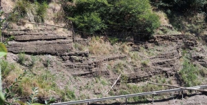
Is it Possible to View the Mittagong Formation?
Not as easily as you might think, and only in artificial cuttings – natural exposures are virtually unknown!
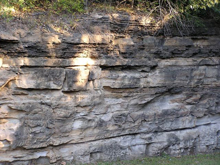 You can look at its type locality at the south-west end of the Gib Tunnel at Mittagong but only by telephoto lens through a security fence (see photo at the top of this page). It's also visible in cuttings along the M31 nearby, but at 110 km/h it's a case of ‘don't blink or you'll miss it’. The best locality is probably the road cutting of the Picton railway overbridge (see photo) though you'll have to park down the road and walk back in if you want to see it hands on.
In our own local area there are a number of rather poor and vulnerable artificial exposures, like the M2 cutting under the Barclay Road over-bridge at North Rocks. But this is currently being plastered in concrete by the North Connex guys and will soon largely disappear. The embankment of the Abbott Road eastbound feed-in lane to the M2 is good too but you can't stop there, nor can you for the south-west embankment of the M2 north-west of the Lane Cove Road interchange at Macquarie Park.
As for natural outcrops, when you stroll around in bushland on the flat ground above Hawkesbury Sandstone dropoffs you may see abundant shards of lateritised shale and siltstone in the soil, but unless you stumble on an erosion gully or creek line you'll be lucky to see anything more.
Sheldon Forest
Sheldon Forest is a pretty good start. Wander down past the scout hall to the sweeping apron of tall Blackbutt forest and you'll be descending from Ashfield Shale onto Mittagong Formation. As the track descends further towards the Hawkesbury Sandstone dropoff there is a marked increase in Turpentines, Sydney Red Gums and many shrubs of sandstone affinity such as banksias. But you don't have to return very far back uphill before shale species like the pea-flowered groundcover Tick Trefoils Desmodium rhytidophyllum and D. varians reappear.
Auluba Reserve
At roughly 3.5 ha, this is probably the largest area of Mittagong Formation bushland in the Lane Cove catchment. It's primarily Blackbutt forest very like lower Sheldon but several other tree species are present, notably Sydney Red Gum, Red Bloodwood and Red Mahogany, and both White and Narrow-leaved Stringybarks are present though these are rare, scattered and sometimes in poor condition. The shrub flora is rich and includes the critically endangered Julian's Hibbertia, H. spanantha. The Sydney region has a greater diversity of hibbertias than any other similar-sized region of Australia and H. spanantha will very likely not be the last new species to be discovered.
North Epping Oval Bushland
This sits above the sandstone on the opposite side of the Lane Cove Valley across from South Turramurra. It's a small area with a very diverse tree community, including Sydney Red Gum, Red Bloodwood, Narrow-leaved Stringybark, Sydney Peppermint, Blackbutt, Turpentine and Christmas Bush. The shrub Laurel Geebung Persoonia laurina, uncommon in the Lane Cove catchment, is quite common here.
Fred Cateson Reserve, Castle Hill
Located at the junction of Showground Road and Gilbert Road, this is a classic locality to walk from shale cap down across the Mittagong Formation and see key plant species. The lower parts of the reserve are Hawkesbury Sandstone but the crest of the rise bordering Gilbert Road carries shale and transitional flora, notably with trees like Grey Gum, White and Thin-leaved Stringybarks, Grey, Broad-leaved and Narrow-leaved Ironbarks, Red Mahoganies and Forest Red Gums. As you descend towards the sandstone, Red Bloodwoods and Black She-oaks assert their presence.
Fagan Park – Carrs Bush, Galston
A stones throw north of Galston, this popular area of grassy park, lakes and bushland straddles the sandstone–shale transition zone, though how much is Mittagong Formation and how much Ashfield Shale is hard to deduce on the ground. The bushland fringe along Arcadia Road is certainly on shale and you can find good specimens of White Stringybark, White Mahogany and Grey Ironbark. This changes north-eastwards, and if you enter the park from Carrs Road you will first see the odd White Mahogany and Grey ironbark but you will immediately enter an area of pure Turpentine forest, almost certainly hosted by Mittagong Formation soils.
This is the third in a series of articles by John Martyn on Sydney’s geology.
Hawkesbury Sandstone Shale Lenses
Most people who live in the upper North Shore and who are interested in bushland, or gardening, or geology, or maybe all three, would be conscious of whether they live on ‘shales’ or ‘sandstones’. They might also be aware that the shales generally overlie the sandstones, or so it would seem. But I had a conversation once with a lady who lives at Duffys Forest who believed that she and her neighbours lived on ‘Wianamatta Shales’. Well it was a reasonable assumption – but incorrect!
The shales that were once extensively quarried at Duffys belong to a thick lens some 140 to 170 m above the base of the Hawkesbury Sandstone, and at these levels and geologic times, the meandering, braided river channels that deposited the sands were starting to pond, and flood plain lagoons became more extensive and persisted for longer, accumulating clays that were preserved beneath further layers of river sand; or torn up and redeposited as sand with shards of shale. Eventually the sand was washed down only in intermittent flood bursts; its sand bars invading the muddy lagoons and the sands interlayering with the clays and silts, creating the transitional Mittagong Formation. The clays then took over as the river basin became a swampy, Triassic coastal lowland, and the Wianamatta Group was formed, but more about Mittagong and Wianamatta in later articles.
Shale Lenses: Form and Size
Hawkesbury Sandstone shale lenses lie sometimes only a few tens of metres or less below the stratigraphic top of the sandstone and they have been mapped and interpreted in different ways over the years. Without drill data it can often be difficult for a field geologist to know if scrappy, lateritised shale floaters and outcrops on a ridgetop are lying within or on top of the sandstone. As such, they were mapped sometimes as outliers of Wianamatta Group or Mittagong Formation, but latterly they have tended to be pushed down into the sandstones. A good example of such ambiguity would be the lateritised shale ridge capping at St Ives Showground, whose topographic setting could fit it into either category. Not only do such shale lenses tend to increase in frequency upwards in the sandstone sequence, but they are more common northwards and towards the coast.
Most lenses are just oversized slivers less than a metre thick and tens to hundreds of metres in lateral extent, and they tend most commonly to consist of laminite: a thinly bedded (mm to cm) alternation of shale, siltstone and sandstone. If you're out and about there are several places you can see them such as the south wall of the Argyle Cut in the Rocks. And on the M2 at Barclay Road overbridge, North Rocks, the NorthConnex guys are excavating a sandstone face with a laminite lens, though this may well soon be concreted over. There's a great example on the cliff top north of Wattamolla, and then there's Beacon Hill, just off Warringah Road, where shale once quarried for ceramics is still visible at the base of the hillside flanking the sports oval. This lens is more substantial and actually yielded numerous fish fossils of freshwater affinity.
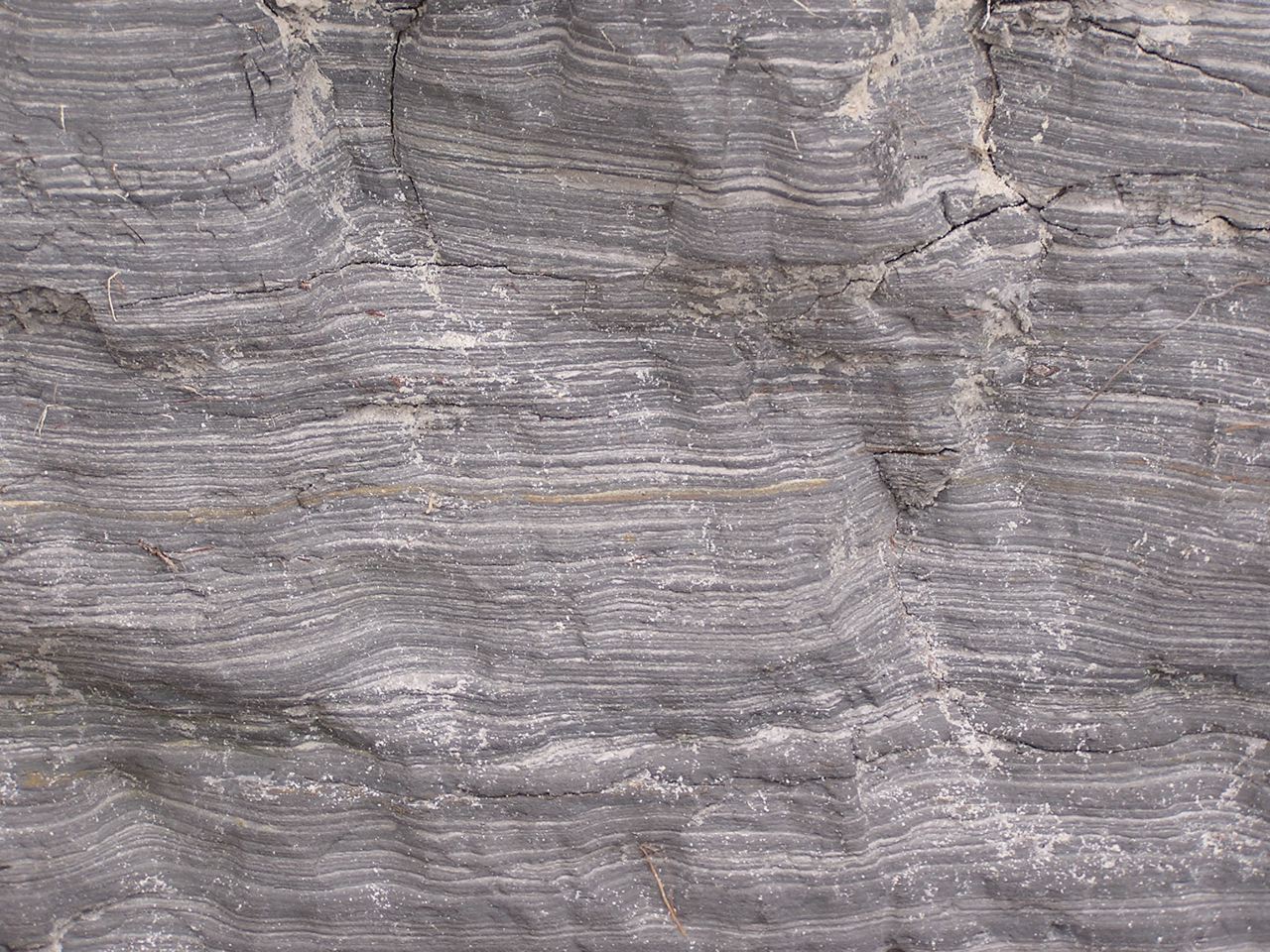
Laminite – millimetre-thick alternating layers of sandstone and shale, Wattamolla cliff top
The Beacon Hill shale lens is thick, but not as thick as the Duffys Forest lens which was 35 m thick before quarrying. Thick also was a lens at Lucas Heights which is of the order of 10 to 20 m. Substantial lenses also occur at Canoelands, Kirrawee, Menai and Darkes Forest, and most of these larger ones tend to carry shale and mudstone in addition to laminite. There is a very readable account published on-line by ANSTO of the Little Forest lens at Lucas Heights, in which the author found little difference between its shale and typical Ashfield Shale of the overlying Wianamatta Group.
In terms of area, the larger lenses may originally have covered several square km, though because they were formed in lagoons and oxbows there is a tendency for them to appear long and narrow. The Darkes Forest lens for example extends along its ridgetop for nearly 4 km and the Duffys Forest lens measures 3 km in outcrop from north to south.
Shale/mudstone overlain by sandstone in former wall of Beacon Hill Quarry
Shale Lenses and their Vegetation
The shale lenses have a marked effect on soils, and this is reflected of course in the vegetation. Shale soils being more fertile have often been cleared for orchards and smallholdings, as at Darkes Forest and Canoelands, though there are significant surviving natural vegetation remnants, as described below.
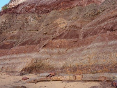
Darkes Forest
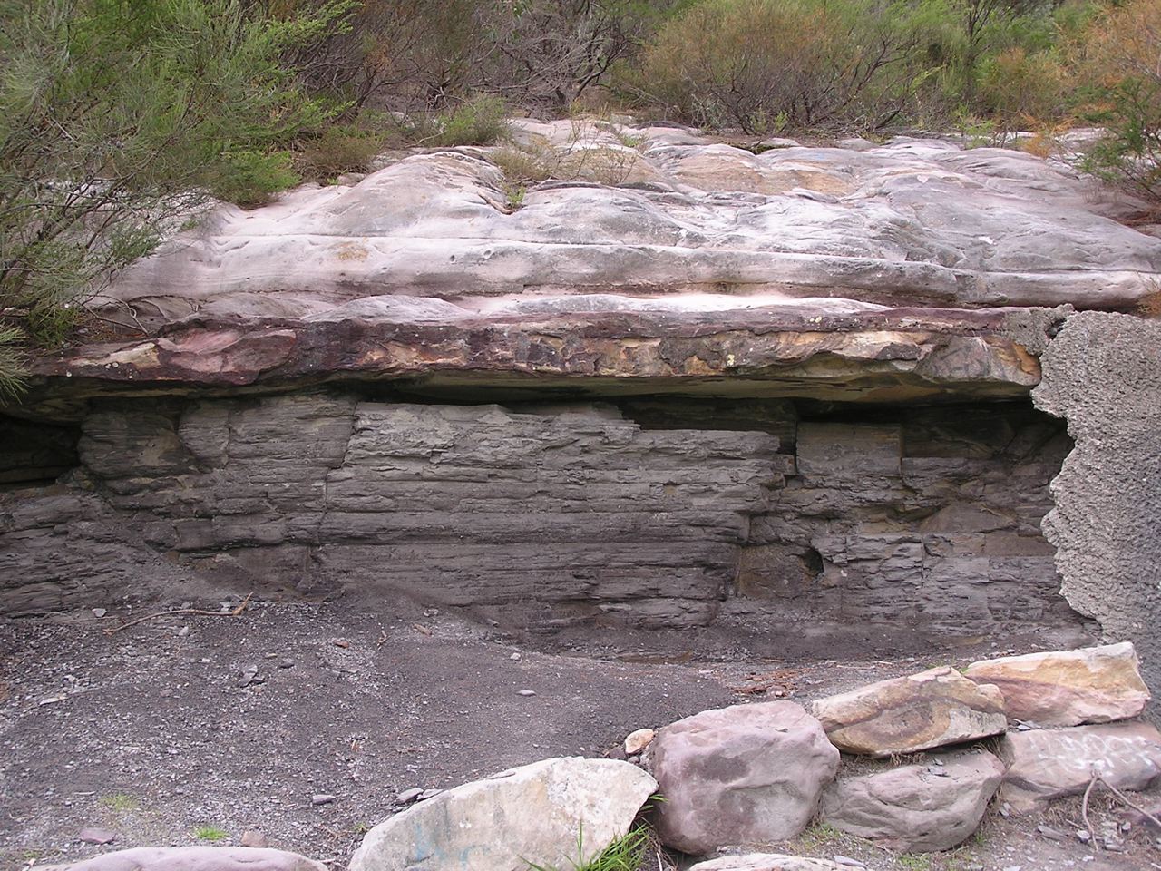
I first stumbled on Darkes Forest by following the signs to the orchards from the Princes Highway, and was surprised to drive past quite tall forests of straight trunked trees; quite a contrast to the sandstone woodlands and shrublands along the highway. The forests are catchment protected so it's unwise to venture too far in, but it's easy to distinguish White Stringybarks, Sydney Peppermints and Sydney Red Gums shading an open floor peppered with tall shrubs of Two-veined Hickory Acacia binervata and a variety of other species including Gymea Lilies. About 200 ha of this forest remains, and has been declared as O'Hares Creek Shale Forest community and listed as endangered. See photo at the top of the page.
Menai
You may drive past the 5 ha Halls Drive Bushland Reserve off New Illawarra Road without noticing it, and be unaware there is any shale in the area, but venture in and you'll see shale fragments in the soil and be confronted with several species of eucalypts of both shale and sandstone affinity. It's probable both White and Common Sandstone Stringybarks are present as are Red Mahoganies, and these are accompanied by Sydney Red Gums and scribbly gums (unsure of species). The last two are perfectly at home on sandstone, but there are also abundant Blackthorns Bursaria spinosa – shrubs more typical of shale terrain. The plant community falls within the broad embrace of the critically endangered Shale Sandstone Transition Forest community.
Kirrawee
The 1:100,000 scale published geology map shows a chain of shale bodies running for 10 km along the ridge line between Sutherland and Cronulla. These are almost entirely built over except for some tiny patches of bushland adjoining Kirrawee railway station. These feature grassy woodland dominated by Grey Ironbarks and are a good example of Sydney Turpentine Ironbark Forest.
Beacon Hill–Frenchs Forest
The only surviving bushland on Beacon Hill itself is totally on sandstone not the shale of the former quarry, but shale lenses mapped around Frenchs Forest nearby carry surviving forest and woodland, though this has been under recent threat from hospital and road construction. A tree that can still be found there is White Mahogany Eucalyptus acmenoides, a shale-loving northern species also common in Edna Hunt Sanctuary near Epping, both areas at the southern limit of its natural range.
Duffys Forest
This semi-rural ridgetop settlement spreads across sandstone and shale, extending over the old shale quarry which has been manicured into a housing estate, country club and golf course. Much of the shale-related bushland was lost in the quarrying but some survives on its north-east and south-west sides. Whether it's truly Duffys Forest plant community may depend on interpretation, as key Duffys species such as Brown Stringybark Eucalyptus capitellata and Caley's Grevillea Grevillea caleyi are either absent or extremely hard to find there.
Trees that can be found include common species like Red Bloodwood, Silvertop Ash, Common Sandstone Stringybark, Sydney Red Gum and Christmas Bush, with a scattering of Blackbutts and Turpentines. The tree flora has affinities with both Duffys Forest and Shale Sandstone Transition Forest communities.
The shale is heavily lateritised, and iron-rich laterite debris have accumulated downslope on sandstone benches and in hollows. Among the species supported in such sites are a wealth of Proteaceae including Waratahs.
Berowra
When you walk from Berowra to Berowra Waters you descend to a firetrail that follows the contour. The hillside here has flattened into a broad bench and there are numerous shale and siltstone fragments in the soil. A shale band has created an aquiclude, wetting the soil to support abundant Umbrella Fern groves, plus thickets of the green-flowered Grevillea mucronulata; not a common plant on the North Shore but very abundant here. The Berowra example is a departure from the ridgetop shale settings and threatened, shale-related plant communities, and if any threatened community is represented there it is Coastal Upland Swamp.
Canoelands
The name of this locality is said to derive from timber getters finding stringybark ‘canoe trees’ with scars from bark removal. The stringybark was said to be Eucalyptus cephalocarpa but there are no known localities of this species north of Merimbula. The few hectares of bushland remnants among the Canoelands orchards carry tall straight stringybarks that are most likely E. globoidea. Such remnants have been mapped as critically endangered Turpentine Ironbark Forest in Hornsby Council's surveys.
This is the second in a series of articles by John Martyn on Sydney’s geology. Click here for his article on the Narrabeen Group.
Towards a Richer Understanding of Local Geology
To many people who are fascinated by Sydney's native flora but have no formal training in geology, the rocks around and about are generally thought of, in simple terms, to consist either of sandstones, shales or volcanic rocks. To express this in a crude stratigraphic way there are believed to be Wianamatta shales lying above Hawkesbury Sandstone which in turn rests on Narrabeen shales. Plus there are the volcanic diatremes of course.
‘Narrabeen shales’ is a term you often hear and read especially when plant communities like Pittwater Spotted Gum Forest and coastal clay heath are described, even in the formal sense by qualified botanists, and generally refers to the Newport Formation. But this term grossly misrepresents the reality, so firstly let’s look at the Narrabeen Group in more detail.
The Narrabeen Group
This group has the widest distribution of any major suite of rocks in the Sydney Basin making up much of the Greater Blue Mountains and covering a vast swathe of the Central Coast and its hinterland. It reaches a maximum thickness of something like 800 m (by comparison, the Hawkesbury Sandstone reaches roughly 250 m in thickness). It could be argued that ‘Narrabeen’ is a poorly chosen type-locality name because, although the group is a collection of 21 distinct formations scattered across the basin, only two of them are present in full on the Northern Beaches, plus just an isolated seashore outcrop of a third one.
Local Formations of the Narrabeen Group
1. Bulgo Sandstone
The ‘isolated seashore outcrop’ is of the Bulgo Sandstone, the top 10 m of which just, but only just, breaks surface on the outer tip of Long Reef. However, out under the sea, deep drilling for the ocean sewage outfall passed through 200 m of Bulgo Sandstone.
Commonly a grey-green colour when fresh, the Bulgo Sandstone can carry, in addition to quartz, a high proportion of grains of volcanic rock of a type similar to those classic columnar-jointed lavas you see on the coast at Kiama; therefore it bears only passing resemblance to the (very quartz-rich) Hawkesbury Sandstone. You can see the Bulgo Sandstone in full at the southern end of the Royal towards Bulgo village where it forms a stunning cliff line; and its pebbly, more quartz-rich lower layers host the famous Figure 8 Pool.
The Bulgo Sandstone's volcanic sand grains break down under weathering to clays leading to the common misconception that the southern slopes of the Royal are over a shale sequence. These clay-rich soils are much deeper and more fertile than those developed over quartz sandstones, and also have inherited plant nutrients from the sandstone's volcanic component, which helps in their hosting of a diverse littoral rainforest community.
In the photo at the top of the page, facing the full brunt of the waves, the topmost 10 m of the Bulgo Sandstone emerges and protects the soft Bald Hill Claystone of the Long Reef rock platform from being washed away into the Tasman Sea.
 2. Bald Hill Claystone
Overlying the Bulgo Sandstone, the Bald Hill Claystone is a strange and remarkable rock by any standards. It's not a shale but the name ‘claystone’ means, like shale and mudstone, it's made largely of clay minerals. It's crumbly but only locally truly shaley.
Also, its kaolinite is stained a deep, dull red-brown (some say chocolate colour) by hematite which, like the kaolinite, was the result of recurrent contemporary weathering of layer upon layer of fine volcanic debris 248 million years ago in early Triassic times. You can see grey-green bands of sandy or gritty debris interlayered with reddish claystones in the cliff faces and platforms at Long Reef.
Bald Hill Claystone at Long Reef is also well known for its Triassic ‘paleosols’ – fossil soil profiles in which you can even recognise ancient root traces.
Red is the prominent colour of the Bald Hill Claystone but you will notice here at Long Reef that the red beds are interlayered with light coloured, greenish-grey bands made of sand grains derived from weathering of volcanic rocks.
In the Northern Beaches, the claystone only supports vegetation on Long Reef Point, though well to the south it's present below the Hawkesbury Sandstone cliffs of the Illawarra Escarpment from the Royal to at least as far as Fitzroy Falls: its formal type locality is actually Bald Hill at Stanwell Tops.
At Long Reef Point it hosts heathland, shrubland and Themeda Grassland, but with a major problem of invasive bitou bush.
3. Newport Formation
The Newport Formation rests above the Bald Hill Claystone via a transitional few metres of a curious, spotted volcanic ash deposit called the Garie Formation.
You can see a thinned version of the Newport Formation in the cliffs of North Garie Head in the Royal, then northwards it dips below the sea before surfacing low on the North Head cliffs – you can view its 15 m thick laminite and ledge-forming flaggy sandstones from the first lookout walking clockwise round the Fairfax Walk. However, it's much easier to see the formation in the cliffs from Narrabeen northwards where it consists mostly of thinly bedded sandstones and laminites with lenses of conglomerate (see photo).
Northwards along the coastline and across Pittwater into the Hawkesbury estuary there is a thickening and coarsening of the sandstones, and you can easily see this on Barrenjoey and Lion Island where only the topmost quarter of their thick sandstone cliffs belongs to the Hawkesbury Sandstone. You can often strain your eyes deciding where one formation finishes and the other begins, though the Newport sandstones tend to have dirtier, rustier weathering surfaces. The sandstones are impure quartz lithic ones and locally interbedded with laminites which are exposed especially north side of Lion Island where the formation has undergone a name change to Terrigal Formation.
The Newport Formation is host to some important plant communities. Its sandstones and laminites of the coastal cliffs weather to a stony, clay-rich soil which supports coastal clay heath and endangered Themeda Grassland. But traverse the peninsula and this all changes to pockets of littoral rainforest intermixed with endangered Pittwater Spotted Gum Forest. The host soils are weathered, thick quartz lithic sandstones with intermittent laminite layers – but definitely not shales.
Thick sandstones persist westwards and upstream into the Hawkesbury estuary but the tree species change, the principal eucalypt becoming Angophora floribunda comprising the Rough-barked Apple–Forest Oak Forest community defined by Smith & Smith in their plant survey projects for Hornsby and Warringah shire councils.
Barrenjoey lighthouse is built on a capping of Hawkesbury Sandstone but the lower two thirds of the headland is coarse-grained, rusty weathering sandstones of the Newport Formation which are the host rocks of the endangered Pittwater Spotted Gum Forest
This is the first in a series of articles by John Martyn describing his exploration of Sydney’s geology.