Displaying items by tag: byles creek
Byles Creek land zoning change approved by council
As reported in STEP Matters Issue 216 Hornsby Council voted in favour of changing the zoning and other conditions in the LEP in relation to land in the Byles Creek Valley.
This decision has now been translated into a planning proposal that has been agreed by the mayor and councillors to go to the state government for their approval.
Once approved by the government, this proposal will allow changes to the R2-zoned land to more environmentally sensitive C4 zoning. This will prevent any further subdivision of the large lots in the subject area with associated wholesale clearing to provide asset protection zones. There will be greater protection of the riparian zone which is the land adjacent to the watercourse, in most places 30 m wide on each side of the creek.
Four years ago members of the Byles Creek Valley Union were told by their local member, Dominic Perrottet, that funds were in place to acquire some of the privately held bushland and he promised that he would take steps to start the process. Despite several follow ups this promise is still to be actioned.
Good news for Byles Creek
In Issue 211 of STEP Matters we wrote about the review being undertaken by Hornsby Council of the planning controls in the Byles Creek area. Local residents have been fighting for years to have the zoning of some large undeveloped lots changed so they cannot be sub-divided into smaller lots leading to clearing of high quality bush that is a wildlife corridor and essential habitat for several threatened species.
The good news is that at the May 2022 meeting Hornsby councillors voted unanimously in favour of implementation of all of the Byles Creek Planning Study recommendations without any changes as below:
- rezone the R2 land within the study area to E4 Environmental Living
- increase the minimum lot size for land to be zoned E4 Environmental Living to 40 hectares
- strengthen the wording of the objectives for minimum lot size, clause 4.1 of the Hornsby Local Environment Plan to protect and enhance existing bushland and significant vegetation
- insert a new Local Provision Clause for Riparian Land into the Hornsby LEP 2013 and provide supporting riparian corridor mapping
- increase community engagement programs targeting the study area
Although there will be more steps along the way with the formal planning proposal etc requiring public comments before it becomes legislation, this has ensured the process will begin.
There are still large lots that will only be protected if they are acquired and conserved. The Byles Creek Valley Union is continuing to meet with our state member, Premier Perrottet to make this happen as promised. However, implementing the study recommendations will improve the level of protection for the rest of the Byles Creek catchment.
Byles Creek Valley should be Protected
Hornsby Council is undertaking a four-month review at a cost of $70,000 into potential rezoning and acquisition of land in Byles Creek Valley that is currently unprotected. Council has come to this conclusion in all reviews and reports in the past.
In 2014 Hornsby Council made a very comprehensive submission to the NSW government pushing for acquisition of Byles Creek Valley land in 2014. In this document council’s expert environmental team stated that:
The Byles Creek catchment has been identified as environmentally significant due to the unique environmental values of the area … The preservation of these lands provides connectivity between the significant vegetation corridor along Byles Creek and Lane Cove National Park. The connectivity of this corridor ensures the ability for species to disperse between reserves and the national park and for the transferral of genetic material. The conservation value of this corridor is further emphasised by its inclusion as a core area in the NSW Biodiversity Investment Opportunities Map as part of the NSW government’s Green Corridors Program.
The valley is noted for the high quality of the water in the Creek that flows into the Lane Cove River. It is used as a reference standard for water quality in the shire.
As a member of the Powerful Owl Coalition, STEP strongly supports the protection of the valley as it links with breeding habitat for the Powerful Owl.
Our thanks to the Byles Creek Valley Union for this information.
Byles Creek Decision
The tremendous efforts of the local community have produced some beneficial outcomes.
Issue 185 of STEP Matters provided an update on the battle by residents of Beecroft and the Beecroft Cheltenham Civic Trust to save bushland from subdivision and development at 79–87 Malton Road. This bushland is the last remaining corridor along Byles Creek between Lane Cove National Park and Pennant Hills Park.
The matter was brought before a Land and Environment Court conciliation conference. However it was inevitable, the final court determination approved the sub-division.
The asset protection zone around the houses to be built will entail the loss of a lot of vegetation but not as much as originally expected. There are conditions requiring the Vegetation and Fauna Management Plans applicable to the asset protection zone to take measures to preserve threatened species such as Leptospernum deanei and a possible nesting site of the Gang-gang Cockatoo. Part of the site (Lot 6 of approximately 1 hectare) will be passed into council hands to be conserved as open space.
A develpoment application for neighbouring land at 77 Malton Road (approx 7000 m2) has also been approved. Unfortunately, 77 trees will be lost for bushfire protection and construction. The owners are prepared to work with council to come to an agreement over the walking track along Byles Creek that will allow the public access to Byles Creek Valley and Lane Cove National Park.
Battle to Preserve the Byles Creek Wildlife Corridor
Beecroft is bearing the brunt of three significant infrastructure developments (North West Rail Link, Epping to Thornleigh Third Track and NorthConnex road tunnel) as well as unit development. These projects have led to the removal of many significant trees including 0.7 hectares of Sydney Turpentine Ironbark Forest which is listed as endangered.
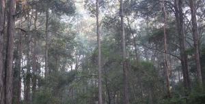
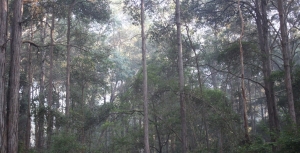
The residents of Malton Road and the Beecroft-Cheltenham Civic Trust have been fighting for many years to save bushland at 79–87 Malton Road from subdivision. If the subdivision application is approved the last remaining corridor of bushland along Byles Creek between Lane Cove National Park and Pennant Hills Park will be lost. It is one branch of Byles Creek that is largely unaffected by urban runoff and it is rare to find such pristine water in urban areas.
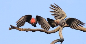
The land is in excellent condition, holding high biodiversity values as recognised by its inclusion on Hornsby Shire Council’s Biodiversity Map, with habitat supporting a range of threatened flora and fauna species including Leptospermum deanei, Genoplesium baueri, the grey-headed flying-fox, Powerful Owls and an endangered population of Gang-gang Cockatoos of ‘significant conservation value as it is the last known breeding population of the species in the Sydney metropolitan area’.
If the land is built on, the bushfire regulations will require most of the blocks to be cleared to create asset protection zones. It is unclear whether all six blocks could be built on in any case because of access and asset protection issues. So it could be that most of the area of bushland would be cleared for construction of only two or three houses.
At the June 2015 Hornsby Council meeting following extensive resident addresses and debate, councillors voted unanimously to make a full and comprehensive submission to the NSW Government to acquire this bushland as regional open space. Members of the Byles Creek Valley Union and Civic Trust members worked hard to compile a comprehensive submission to the NSW Government, to augment that prepared by council.
In December the deferred application was refused by council on the grounds that the ecological assessments provided by the applicant were inadequate. Precise confirmation is needed of the possible presence of two plant species: the vulnerable Leptospermum deanei and the endangered Genoplesium baueri, an orchid. It would not be known until March – when the orchid flowers – whether it grows on the site.
The applicant has not been prepared to obtain extra information about this orchid and the applicant then appealed the decision before the Land and Environment Court.
A report commissioned by council by ecological consultant Peter Smith stated the entire site:
… is worthy of purchase and management as a bushland reserve ...
If funding is not available to purchase the land, then further assessment is needed of the impact of the proposed subdivision and residential development of this land …
A patch of bushland like this, with so many large, old trees, forms a crucial piece of habitat for so much of our biodiversity and its loss would be a loss for the community and Sydney as a whole …
He also questioned whether offsets are available in respect of the land to be cleared.
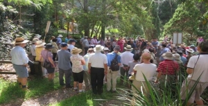
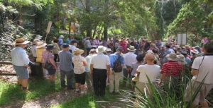
On 10 March a conciliation conference was held on site. Over 100 local residents arrived on a very steamy morning to hear very detailed oral submissions from four local residents explaining their reasons for opposing the application.
Further negotiations are going on via the Land and Environment Court conciliation process. This is due to be finalised on 6 May.
The residents are still fighting with all their might. They are pushing for the proceeds from the council sale of a church hall in Cheltenham to go towards purchasing the land. See www.2119.org.au for the full story. The group has also created a Facebook page for Mikey the Powerful Owl that is frequently seen in the valley.
Please write to the Hornsby councillors to express support for acquiring the land so this precious bushland can be preserved.

