
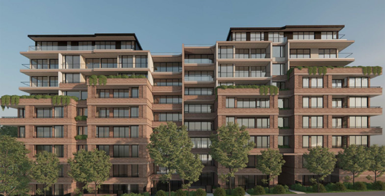
We all feel helpless in the face of the level of the development approvals happening in Sydney, particularly in the Transport Oriented Development (TOD) areas, such as Gordon and Lindfield. But there are already several applications under the low to mid-rise housing provisions that allow nine storey apartment buildings within 400 m of town centres. The focus is currently on apartment buildings where developers see the most opportunity for profit but the low to mid-rise housing provisions will see townhouse and terrace type development popping up within 800 m of town centres replacing single dwellings and gardens with concrete.
We need more housing but no current NSW government strategy properly accounts for community needs such as infrastructure and the characteristics that make a neighbourhood comfortable to live in and, of course, the needs to preserve our natural environment, canopy and wildlife.
Over the last two years the NSW government has introduced a stream of planning legislation including non-refusal standards that override local controls, reduced community and council consultation, and created the Development Coordination Authority that issues approvals in place of agencies such as the Rural Fire Services and the Environment Protection Authority removing their input from public view.
Friends of Ku-ring-gai Environment (FOKE) has undertaken a massive effort in reviewing and writing submissions on around 35 apartment developments totalling over 4,700 dwellings in Ku-ring-gai. Their website and newsletters provide details of what is being imposed on our community. Ku-ring-gai Council has also lodged detailed submissions. These have led to some minor plan modifications but many fundamental problems remain.
Submissions are needed because the applications are usually deficient in many respects. Proponents seek to flout the Apartment Design Guide (ADG) and Ku-ring-gai Development Control Plan (DCP). Although the ADG provides guidance, it only carries legal force through the housing SEPP. The DCP criteria guides are not mandatory. These documents have an important purpose of maintaining quality and amenity and should not be ignored. In addition, applications are regularly made that seek variations to genuine development standards such as maximum heights, floor space ratios and minimum setbacks to the proponent's advantage. It is so unfair that the community members, in their own time and own cost, are doing detailed reviews to assure accountability and better outcomes that an efficient government assessment team should be doing.
Cumulative impacts on our environment
One of the most important features of Ku-ring-gai is our environment, our bushland containing tall trees, rich biodiversity and critically endangered ecological communities plus the remnant and planted trees that line our streets and gardens. The retention of our trees and garden vegetation is essential for both our quality of life and survival of the unique range of wildlife
A quick review of the location and size of the development applications on the NSW Department of Planning Major Projects website reveals that the TOD areas cannot possibly retain any of their previous character. The level of construction will have flow on effects on the surrounding neighbourhoods and environment.
Example 1. Onsite hydrological impacts
Deep excavation is required to build carparks for the large number of residents in these tall apartment buildings. This will cut into rock that may have structural discontinuities, aquifers and other groundwater systems.
Examples of the impacts and management required is described in the hydrogeological assessment and dewatering plan report by Geotesta for 2−8 Highgate Road, Lindfield, that:
Predicted groundwater inflows during the twelve-month excavation and construction period total approximately 2.48 ML and ongoing inflows post construction.
The groundwater analysis identified exceedances in key parameters including acidity, turbidity, salinity, and nutrients, confirming that onsite treatment will be required prior to discharge or reuse.
Drawdown-related risks to nearby assets such as seepage and land settlement, including the heritage conservation areas to the northeast, the railway corridor to the southwest, and environmental receptors associated with the Honeysuckle Creek and Killara Reservoir Notification Area.
Example 2. Downstream hydrological impacts
The Geotesta report points out the large neighbouring area that is affected by deep excavation:
Groundwater drawdown is expected to extend up to ~300 m from the shoring wall, with a maximum drawdown of 7.46 m adjacent to the wall, reducing to ~1 m at the nearest Heritage Conservation Area.
Resulting settlement in overlying soils is predicted to be minimal, with a maximum of ~7.7 mm at the shoring wall, below the 10 mm limit for sensitive brick structures.
Despite these predictions, site conditions may vary due to heterogeneity in rock permeability, seasonal groundwater fluctuations, or unforeseen events.
This is just one development. What will be the impact of several similar developments nearby on the existing houses in the nearby heritage area? This land is part of the catchment that leads to Gordon Creek and Garigal National Park. What will be the impact of changes in direction and level of the flow of groundwater on the integrity of the creeks leading from this area? Will the health of the street trees and bushland be affected?
Example 3. Stormwater
This multitude of apartment buildings along the spine of the Pacific Highway is reducing the areas of soil that can absorb rainfall. During a rainfall event the volume of stormwater will increase significantly leading to erosion and the risk of flooding of neighbouring properties and roads. This is one of many infrastructure costs that have to be borne by council as stormwater systems will probably need to be upgraded. Council has completed the Middle Harbour - Northern Catchments Flood studies. How much allowance has been made for all the new development?
Example 4. Loss of tree canopy
Large numbers of trees are being lost as these apartments are developed via consolidation of several land lots. The Planning Department is giving a much higher priority to adding housing than to retaining and planting more trees despite the pronouncements about the goal of a 40% tree canopy cover. Insufficient deep soil planting is being added to support canopy trees. The KLEP requires 50% provision of deep soil whereas the TOD requirements allow for only 30%. The survival of established street plantings is being jeopardised by the close proximity of shade from tall buildings and new driveways close to root zones.
Example 5. Biodiversity
Ultimately there is a loss of habitat and foraging area for wildlife. The imposition of tall buildings along the top of the Pacific Highway ridge will act as an impediment to the movement of many species of birds that migrate from north to south.