Berowra Valley bushland stretches from south of The Lakes of Cherrybrook to the Hawkesbury River. The valley has a long history of reservation, from 1934 up to 2012. The valley currently contains a complex system of national parks, a regional park, nature reserves and an Aboriginal area.
The basis of Muogamarra Nature Reserve goes back to 1933 and this park, from Cowan to the Hawkesbury River, is still enjoyed for six weekends of the year by the public.
In 1964 Elouera Bushland Natural Park (640 hectares) was formed from bushland stretching from Boundary Road, Pennant Hills, to just north of the Riffle Range at Hornsby. For 24 years this park was managed by a group of honorary trustees appointed by the Minister of Lands. The first president of the Trust in 1964 was the Hon Max Ruddock MP, father of the present mayor of Hornsby Shire Council.
In 1987 Berowra Valley Bushland Park was gazetted. It included Elouera Bushland Natural Park but it now extended all the way to Berowra and Hornsby Shire Council was appointed trustee by the Minister for Lands.
Further land acquisitions were made and in 1998 these lands became Berowra Valley Regional Park, an area of over 3800 hectares. Because of the high value of this land, the majority of the land was reclassified as a national park in 2012 (3876 hectares). Only 9 hectares remain as regional park along some suburban interfaces, specifically to allow dog walking.
The Friends of Berowra Valley grew out of all these changes and in 2004 published A Guide to Berowra Valley Regional Park. They have also published a map of the park, available from STEP.
While Elouera Bushland Natural Park was evolving to a National Park, other areas were being incorporated into the reserve system. In 1979 Marramarra National Park, an area of 11,759 hectares, was gazetted in the northern part of the Valley, from just north of Berowra Waters to the Hawkesbury River and west to Old Northern Road.
In 1997 Mount Kuring-gai Aboriginal Area (0.6 hectares) was reserved and in 2017 a Statement of Management Intent was written to help conserve its special cultural value.
Dural Nature Reserve was reserved in 2003 from the former Dural State Forest. With additional lands added, it is now 35.58 hectares.
With the complex history of reservation go the names of many extraordinary people. Over the years many people have lobbied, collected data, and been part of the dissemination of information to the public, but to me three names stand out.
 In 1967 Dr Joyce Vickery (1908–79), a botanist with the Royal Botanic Gardens, donated over 100 acres (40.5 hectares) of land in the Hornsby Valley for inclusion into Elouera Bushland Park.
John Tipper (1886–1970), an engineer, leased the land to become Muogamarra Nature Reserve in 1933 and opened it to the public in 1935. In 1987 it became the Nature Reserve of the same name managed by National Parks and Wildlife Service.
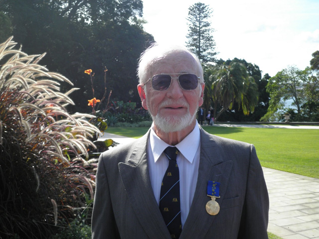
Robert (Bob) Salt was awarded a Centenary Medal in 2001 and in 2011 he was awarded an OAM for service to conservation and the environment through a range of organisations in the North Sydney region (see photo). He has worked for the conservation and effective management of Berowra Valley bushland since 1962 to the present day.
Not all the bushland in the valley is managed by the National Parks and Wildlife Service. Hornsby Council manages large areas, there is Crown land and there is an abundance of private bushland as well. More battles for the valley may be before us.
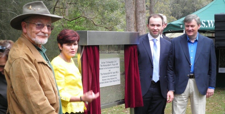
Photo at the top of the page is the opening of Berowra Valley National Park in 2012 at Crosslands: Bob Salt, Robyn Parker (Minister for the Environment), Matt Kean (Member for Hornsby) and Robert Browne (Hornsby Councillor) (both photos Noel Rosten)
Robin Buchanan